About ForeFlight Mobile EFB
Download for a 30-day free trial. ForeFlight is the essential, integrated flight app that makes planning, flying, and logging flights a joy. ForeFlight delivers advanced flight planning capabilities, terminal procedure...
Download for a 30-day free trial. ForeFlight is the essential, integrated flight app that makes planning, flying, and logging flights a joy.
ForeFlight delivers advanced flight planning capabilities, terminal procedure charts, enroute navigation charts, moving map, synthetic vision, hazard awareness, optional Jeppesen charts, a comprehensive library of market-leading weather information and visualization features, a large library of advanced aircraft performance profiles, customizable checklists, integration with a wide range of certified avionics and portable ADS-B and GPS receivers for inflight weather and data, a built-in documents catalog and cloud document capability for management of aircraft and flight operations publications, an easy-to-use pilot logbook for keeping track of flight experience, and so much more. ForeFlight is backed by our Pilot Support Team who delivers amazingly fast, accurate, and friendly customer service.
Please note: Location is used to enable a moving map and to record track logs, the camera is used to attach photos to logbook, push notifications are used for important bulletins and flight alerts, and contacts are used to add people to flights.
ForeFlight requires a subscription. Visit our website for more information on the available plan levels.
FLIGHT PLANNING, BRIEFING, & FILING
Plan flights with Touch Planning on the Map or full-featured form-based Flights view. Tap out a route in seconds and quickly see if flights will be affected by weather or TFRs. Helpful Route, Altitude, and Procedure Advisors make planning easy and accurate. Generate a graphical preflight briefing and file your flight plan directly from the app. Print a professional-grade Navlog for inflight reference.
WEATHER
Interactive weather layers include animated radar, global satellite and winds aloft, global icing, turbulence, and surface analysis, graphical AIR/SIGMETs, flight category, visibility, and more. View decoded METARs, TAFs, and MOS forecasts. Thoughtfully organized Imagery view puts a full range of forecast tools at your fingertips.
PLATES, CHARTS, & MAPS
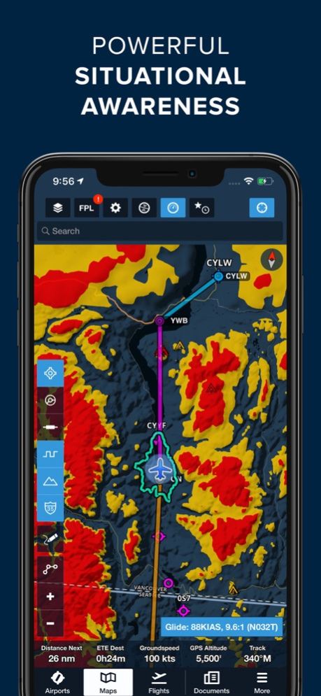
Both VFR and IFR operations are covered with all of the essentials required for planning and navigation: data-driven Aeronautical Maps, VFR Sectionals, High/Low Enroute charts, SIDs, STARs, approach and taxi charts, and terrain, satellite, and street map views.
GEO-REFERENCED APPROACHES & TAXI CHARTS
Plates and taxi charts enable the real time display of your GPS location on the chart. They can also be overlaid on the Maps view along with weather and hazards for the ultimate situational awareness.
GLOBAL HAZARD AWARENESS TECHNOLOGY
Plan and fly with more confidence in all conditions and terrain. Top-down-view Hazard Advisor map layer, Terrain Profile View, and 3D Synthetic Vision seamlessly integrate into the map display to depict a clear picture of terrain and obstacle hazards anywhere in the world. When paired with an AHRS source, Synthetic Vision provides a backup attitude display.
LOGBOOK
Logbook makes it easy to log and share flights, track hours, review currency, record certificates and ratings, receive electronic instructor endorsements, and create experience reports. Your data is automatically synced across all your devices and protected in secure cloud storage.
ADDITIONAL FEATURES INCLUDE:
Built-in documents catalog with FAR/AIM, charts supplements, and more
Airport, FBO, and fuel price information for thousands of locations
Dynamic data-driven Aeronautical Maps
Weight & Balance
Glide Advisor
Expected route and EDCT flight notifications
Automatic over-the-air data updates
Chart color inversion for better night flying experience
Access to web planner
REVIEWS
Flying Magazine Editor's Choice 2012, 2013, 2014, 2017
App of the Year, Aviation Consumer, July 2011
Best Selling iPad Aviation App: 2010, 2011, 2012
"Best app for IFR" - Aviation Consumer
"One of the most popular and most-respected aviation apps available" - Sporty's Pilot Shop
Apr 25, 2024
Version 16.4.1
Reported Turbulence Map Layer
• Plan smoother and safer flights by seeing where pilots are actually encountering smooth air or turbulence with this powerful new map layer.
• The layer displays individual turbulence reports as color-coded dots representing turbulence intensity, which you can tap on to view the report’s age (up to approximately six hours old), altitude, airspeed, and the type code and wake category of the aircraft from which the report originated, as well as a list of nearby reports.
• An altitude slider is available to filter turbulence reports by altitude, and the Reported Turbulence layer is also available in Profile View, allowing you to view reports at all altitudes along your planned route.
• The new layer receives its data from Sentry and Sentry Plus devices, which automatically measure inflight turbulence and transmit de-identified reports via the ForeFlight Mobile app after each flight.
• Reported Turbulence is available as two subscription add-ons: Reported Turbulence (Low) provides access to all turbulence reports up to 14,000 feet, while the Reported Turbulence (All) add-on grants access to reports at all altitudes.
• The Reported Turbulence (Low) add-on is available free of charge to owners of Sentry or Sentry Plus devices on Pro Plus subscription plans and above who register their Sentry’s serial number at plan.foreflight.com/account. A 50% discount on the Reported Turbulence (All) layer is also provided to customers who register their Sentry.
US Lowest-Tilt Radar Map Layer
• See where precipitation is likely reaching the ground with the return of this popular map layer sporting lower latency and improved spatial resolution.
• The Radar (Lowest-Tilt) layer only depicts radar returns obtained at the lowest angle of the radar’s sweep, which better correspond to where precipitation is reaching the ground in the form of rain or snow.
• The new layer benefits from significantly reduced latency of 6 minutes or less and also provides enhanced spatial resolution, although the layer doesn’t yet support storm track markers.
• The Radar (Lowest-Tilt) layer is currently limited to the US and South Korea.
Runway Analysis: Landing Factor Selector
• Separately calculate a flight’s landing distance during pre-flight planning and before arrival to better comply with your SOP and industry guidance on mitigating runway excursions.
• While in the Landing Analysis or Emergency Return views, tap either the Surface Condition or Landing Factor fields to access the new Landing Factor Selector.
• Select either Pre-Flight / Dispatch or In-Flight / LDTA under Phase of Flight to access different options for surface condition and landing factor, with the latter also supporting runway condition codes in place of actual surface conditions.
• Selecting different surface conditions in either mode will also automatically filter the list of available landing factors, which are more clearly labeled with both percentage and factor multiplication equivalents.
• Available with ForeFlight’s Runway Analysis add-on for supported jet and select turboprop aircraft.
Runway Analysis: TOLD Card
• Brief your takeoff or landing with a clean and printer-friendly summary of the most critical pieces of information produced by Runway Analysis.
• In the Takeoff or Landing Analysis views, tap the new TOLD button next to the Summary button in the upper-right corner to view the TOLD card, and tap the Send To button in the top-right to share or print it.
• Available with ForeFlight’s Runway Analysis add-on for supported jet and select turboprop aircraft.
Previous Versions
Here you can find the changelog of ForeFlight Mobile EFB since it was posted on our website on 2016-10-01 18:43:06.
The latest version is 16.4.1 and it was updated on 2024-04-26 13:42:30. See below the changes in each version.
ForeFlight Mobile EFB version 16.4.1
Updated At: 2024-04-25
Changes: Apr 25, 2024
Version 16.4.1
Reported Turbulence Map Layer
• Plan smoother and safer flights by seeing where pilots are actually encountering smooth air or turbulence with this powerful new map layer.
• The layer displays individual turbulence reports as color-coded dots representing turbulence intensity, which you can tap on to view the report’s age (up to approximately six hours old), altitude, airspeed, and the type code and wake category of the aircraft from which the report originated, as well as a list of nearby reports.
• An altitude slider is available to filter turbulence reports by altitude, and the Reported Turbulence layer is also available in Profile View, allowing you to view reports at all altitudes along your planned route.
• The new layer receives its data from Sentry and Sentry Plus devices, which automatically measure inflight turbulence and transmit de-identified reports via the ForeFlight Mobile app after each flight.
• Reported Turbulence is available as two subscription add-ons: Reported Turbulence (Low) provides access to all turbulence reports up to 14,000 feet, while the Reported Turbulence (All) add-on grants access to reports at all altitudes.
• The Reported Turbulence (Low) add-on is available free of charge to owners of Sentry or Sentry Plus devices on Pro Plus subscription plans and above who register their Sentry’s serial number at plan.foreflight.com/account. A 50% discount on the Reported Turbulence (All) layer is also provided to customers who register their Sentry.
US Lowest-Tilt Radar Map Layer
• See where precipitation is likely reaching the ground with the return of this popular map layer sporting lower latency and improved spatial resolution.
• The Radar (Lowest-Tilt) layer only depicts radar returns obtained at the lowest angle of the radar’s sweep, which better correspond to where precipitation is reaching the ground in the form of rain or snow.
• The new layer benefits from significantly reduced latency of 6 minutes or less and also provides enhanced spatial resolution, although the layer doesn’t yet support storm track markers.
• The Radar (Lowest-Tilt) layer is currently limited to the US and South Korea.
Runway Analysis: Landing Factor Selector
• Separately calculate a flight’s landing distance during pre-flight planning and before arrival to better comply with your SOP and industry guidance on mitigating runway excursions.
• While in the Landing Analysis or Emergency Return views, tap either the Surface Condition or Landing Factor fields to access the new Landing Factor Selector.
• Select either Pre-Flight / Dispatch or In-Flight / LDTA under Phase of Flight to access different options for surface condition and landing factor, with the latter also supporting runway condition codes in place of actual surface conditions.
• Selecting different surface conditions in either mode will also automatically filter the list of available landing factors, which are more clearly labeled with both percentage and factor multiplication equivalents.
• Additional settings related to landing factor selection are also available in More > Aircraft > Field Performance > Landing
• Available with ForeFlight’s Runway Analysis add-on for supported jet and select turboprop aircraft.
Runway Analysis: TOLD Card
• Brief your takeoff or landing with a clean and printer-friendly summary of the most critical pieces of information produced by Runway Analysis.
• In the Takeoff or Landing Analysis views, tap the new TOLD button next to the Summary button in the upper-right corner to view the TOLD card, and tap the Send To button in the top-right to share or print it.
• Available with ForeFlight’s Runway Analysis add-on for supported jet and select turboprop aircraft.
ForeFlight Mobile EFB version 16.4
Updated At: 2024-04-22
Changes: Apr 22, 2024
Version 16.4
Reported Turbulence Map Layer
• Plan smoother and safer flights by seeing where pilots are actually encountering smooth air or turbulence with this powerful new map layer.
• The layer displays individual turbulence reports as color-coded dots representing turbulence intensity, which you can tap on to view the report’s age (up to approximately six hours old), altitude, airspeed, and the type code and wake category of the aircraft from which the report originated, as well as a list of nearby reports.
• An altitude slider is available to filter turbulence reports by altitude, and the Reported Turbulence layer is also available in Profile View, allowing you to view reports at all altitudes along your planned route.
• The new layer receives its data from Sentry and Sentry Plus devices, which automatically measure inflight turbulence and transmit de-identified reports via the ForeFlight Mobile app after each flight.
• Reported Turbulence is available as two subscription add-ons: Reported Turbulence (Low) provides access to all turbulence reports up to 14,000 feet, while the Reported Turbulence (All) add-on grants access to reports at all altitudes.
• The Reported Turbulence (Low) add-on is available free of charge to owners of Sentry or Sentry Plus devices on Pro Plus subscription plans and above who register their Sentry’s serial number at plan.foreflight.com/account. A 50% discount on the Reported Turbulence (All) layer is also provided to customers who register their Sentry.
US Lowest-Tilt Radar Map Layer
• See where precipitation is likely reaching the ground with the return of this popular map layer sporting lower latency and improved spatial resolution.
• The Radar (Lowest-Tilt) layer only depicts radar returns obtained at the lowest angle of the radar’s sweep, which better correspond to where precipitation is reaching the ground in the form of rain or snow.
• The new layer benefits from significantly reduced latency of 6 minutes or less and also provides enhanced spatial resolution, although the layer doesn’t yet support storm track markers.
• The Radar (Lowest-Tilt) layer is currently limited to the US and South Korea.
Runway Analysis: Landing Factor Selector
• Separately calculate a flight’s landing distance during pre-flight planning and before arrival to better comply with your SOP and industry guidance on mitigating runway excursions.
• While in the Landing Analysis or Emergency Return views, tap either the Surface Condition or Landing Factor fields to access the new Landing Factor Selector.
• Select either Pre-Flight / Dispatch or In-Flight / LDTA under Phase of Flight to access different options for surface condition and landing factor, with the latter also supporting runway condition codes in place of actual surface conditions.
• Selecting different surface conditions in either mode will also automatically filter the list of available landing factors, which are more clearly labeled with both percentage and factor multiplication equivalents.
• Additional settings related to landing factor selection are also available in More > Aircraft > Field Performance > Landing
• Available with ForeFlight’s Runway Analysis add-on for supported jet and select turboprop aircraft.
Runway Analysis: TOLD Card
• Brief your takeoff or landing with a clean and printer-friendly summary of the most critical pieces of information produced by Runway Analysis.
• In the Takeoff or Landing Analysis views, tap the new TOLD button next to the Summary button in the upper-right corner to view the TOLD card, and tap the Send To button in the top-right to share or print it.
• Available with ForeFlight’s Runway Analysis add-on for supported jet and select turboprop aircraft.
ForeFlight Mobile EFB version 16.3.1
Updated At: 2024-03-28
Changes: Mar 28, 2024
Version 16.3.1
Aeronautical Map Drawer
• A consolidated drawer now houses all Aeronautical Map toggles and settings, optimizing space when you aren’t using it.
• Tap the new button in the lower-left corner of the Maps view with the Aeronautical Map layer enabled to open the drawer and toggle map elements like airports, airspace, waypoints, airways, terrain, and more, or tap the ellipses button at the very bottom to access Aeronautical Map Settings.
• Below the toggles are new Aeronautical Modes for IFR High, IFR Low, and VFR, which you can select to quickly change altitude-based map elements like waypoints, navaids, airways, ATC boundaries, and VFR map elements.
• Any changes you make to the quick toggles or settings only apply to the currently selected Aeronautical Mode, so you can configure each mode with separate toggle selections and settings and change all of them at once just by switching modes.
• The Aeronautical Map Drawer will automatically close after a period of inactivity - 10 seconds by default. You can increase or decrease this time using the “Auto-Dismiss After” setting at the top of the Aeronautical Map Settings menu. You can also tap anywhere on the map to close the drawer.
Basic Navlog Template
• Tailored for VFR pilots, the new Basic Navlog offers a cleaner format resembling a traditional navlog.
• From the Flights view, tap the Navlog button next to Briefing at the top of a flight plan to open the Navlog, then tap the Settings cog in the top-right to select the Basic template.
• The Basic Navlog also has better print quality compared to the other Navlog formats, especially when using half-sheet printing.
Power Lines on Basemap
• Plan and fly with global power line depictions on ForeFlight's high-resolution Basemap for enhanced hazard awareness.
• Power lines are depicted on the map in a distinct maroon color, presented as lines with hash marks for easy identification.
• The Basemap is usually paired with the Aeronautical Map and can be seen by turning off other chart layers that cover it. Download the high-resolution basempa for other regions in More > Downloads > Data Settings.
Sentry Allows Cellular Data
• Access internet data in ForeFlight via your device’s cellular connection even while connected to any Sentry-family ADS-B receiver to check internet-sourced radar, amend a flight plan prior to takeoff, and more.
• Internet-based map layers will remain selectable while connected to Sentry so you can easily jump between them and live ADS-B weather while receiving cellular data.
New Airspace Settings
• Tailor the display of airspace on ForeFlight's Aeronautical Map with global Class E airspace filtering and more granular control over different types of Special Use Airspace.
• Previously only applied to US airspace, the Class E toggle now shows or hides Class E airspace globally. This toggle has also been grouped with TRSA and Mode C toggles in the Controlled Airspace section of the Aeronautical Map Settings menu.
• The new Special Use Airspace section of the Settings menu combines existing toggles for Parachute Areas and ADIZ with new, more granular toggles: "Prohibited & Restricted," "MOA, Alert, and Training," "Caution, Danger, & Warning," "TRA & TSA," and "Other."
• Access these and other airspace settings via the Settings button at the bottom of the new Aeronautical Map Drawer.
Southern Africa VFR Charts
• Detailed VFR charts providing comprehensive local airspace details are now accessible for several countries across southern Africa: Angola, Botswana, Eswatini, Lesotho, Mozambique, Namibia, South Africa, Zambia, and Zimbabwe.
• You can add this region to your ForeFlight subscription via the ForeFlight website and select countries in More > Downloads > Region Settings to download charts.
ForeFlight Mobile EFB version 16.3
Updated At: 2024-03-26
Changes: Mar 26, 2024
Version 16.3
Aeronautical Map Drawer
• A consolidated drawer now houses all Aeronautical Map toggles and settings, optimizing space when you aren’t using it.
• Tap the new button in the lower-left corner of the Maps view with the Aeronautical Map layer enabled to open the drawer and toggle map elements like airports, airspace, waypoints, airways, terrain, and more, or tap the ellipses button at the very bottom to access Aeronautical Map Settings.
• Below the toggles are new Aeronautical Modes for IFR High, IFR Low, and VFR, which you can select to quickly change altitude-based map elements like waypoints, navaids, airways, ATC boundaries, and VFR map elements.
• Any changes you make to the quick toggles or settings only apply to the currently selected Aeronautical Mode, so you can configure each mode with separate toggle selections and settings and change all of them at once just by switching modes.
• The Aeronautical Map Drawer will automatically close after a period of inactivity - 10 seconds by default. You can increase or decrease this time using the “Auto-Dismiss After” setting at the top of the Aeronautical Map Settings menu. You can also tap anywhere on the map to close the drawer.
Basic Navlog Template
• Tailored for VFR pilots, the new Basic Navlog offers a cleaner format resembling a traditional navlog.
• From the Flights view, tap the Navlog button next to Briefing at the top of a flight plan to open the Navlog, then tap the Settings cog in the top-right to select the Basic template.
• The Basic Navlog also has better print quality compared to the other Navlog formats, especially when using half-sheet printing.
Power Lines on Basemap
• Plan and fly with global power line depictions on ForeFlight's high-resolution Basemap for enhanced hazard awareness.
• Power lines are depicted on the map in a distinct maroon color, presented as lines with hash marks for easy identification.
• The Basemap is usually paired with the Aeronautical Map and can be seen by turning off other chart layers that cover it. Download the high-resolution basempa for other regions in More > Downloads > Data Settings.
Sentry Allows Cellular Data
• Access internet data in ForeFlight via your device’s cellular connection even while connected to any Sentry-family ADS-B receiver to check internet-sourced radar, amend a flight plan prior to takeoff, and more.
• Internet-based map layers will remain selectable while connected to Sentry so you can easily jump between them and live ADS-B weather while receiving cellular data.
New Airspace Settings
• Tailor the display of airspace on ForeFlight's Aeronautical Map with global Class E airspace filtering and more granular control over different types of Special Use Airspace.
• Previously only applied to US airspace, the Class E toggle now shows or hides Class E airspace globally. This toggle has also been grouped with TRSA and Mode C toggles in the Controlled Airspace section of the Aeronautical Map Settings menu.
• The new Special Use Airspace section of the Settings menu combines existing toggles for Parachute Areas and ADIZ with new, more granular toggles: "Prohibited & Restricted," "MOA, Alert, and Training," "Caution, Danger, & Warning," "TRA & TSA," and "Other."
• Access these and other airspace settings via the Settings button at the bottom of the new Aeronautical Map Drawer.
Southern Africa VFR Charts
• Detailed VFR charts providing comprehensive local airspace details are now accessible for several countries across southern Africa: Angola, Botswana, Eswatini, Lesotho, Mozambique, Namibia, South Africa, Zambia, and Zimbabwe.
• You can add this region to your ForeFlight subscription via the ForeFlight website and select countries in More > Downloads > Region Settings to download charts.
ForeFlight Mobile EFB version 16.2.1
Updated At: 2024-03-04
Changes: Mar 4, 2024
Version 16.2.1
MORA/LSALT Grid Overlay
• Identify the altitudes to avoid along your flight route by referencing the Minimum Off-Route Altitude (MORA), or Lowest Safe Altitude (LSALT) in Australia, directly on the map.
• Altitudes, in feet, are represented as the first number indicating thousands and the second, smaller number indicating hundreds within the grid.
• The grid initially is presented as a 5ºx5º grid, which dynamically condenses to 1ºx1º as you zoom in on the map.
• Altitudes under 10,000 feet are depicted in green, suggesting lower terrain/obstacle heights, while altitudes exceeding 10,000 feet are highlighted in red, indicating significantly higher terrain/obstacles.
• This new setting is enabled by default but can be disabled in Map Settings > Grid MORA/LSALT (ft) while the Aeronautical Map is active.
Logbook: Preview Student Comments
• Instructors can now review student comments prior to signing remote entries, ensuring transparency and efficiency. Easily append notes, sign, and save without hassle.
• New signature requests appear in Logbook > Drafts & Requests with a preview of the student’s comments.
• In addition to existing functionalities, instructors can now save the draft along with student comments to their personal logbook. This ensures that student comments are retained for future reference, enabling the instructor to maintain accurate records.
Aircraft on Same Runway Alerts
• Receive critical safety alerts before entering a runway, notifying you of other aircraft occupying the runway.
• The prominent visual and audio alerts specify which runway the traffic target is currently using or approaching and visually highlight the traffic target in red.
• Customize the types of alerts you receive or disable them entirely in Map Settings > Alerts.
• Available while receiving traffic information from any ADS-B or FLARM device.
Controlled Airspace Alerts: RMZs Added
• Controlled airspace alerts now encompass RMZs along with their frequencies, providing convenient and timely reference as you approach airspace.
• Visibility of RMZ frequencies requires a European subscription, while RMZ alerts are accessible to all users.
• You can optionally disable RMZs in airspace alerts and customize the alerts in other ways in Map Settings > Alerts > Airspace & NOTAMs.
ForeFlight Mobile EFB version 16.2
Updated At: 2024-02-27
Changes: Feb 27, 2024
Version 16.2
MORA/LSALT Grid Overlay
• Identify the altitudes to avoid along your flight route by referencing the Minimum Off-Route Altitude (MORA), or Lowest Safe Altitude (LSALT) in Australia, directly on the map.
• Altitudes, in feet, are represented as the first number indicating thousands and the second, smaller number indicating hundreds within the grid.
• The grid initially is presented as a 5ºx5º grid, which dynamically condenses to 1ºx1º as you zoom in on the map.
• Altitudes under 10,000 feet are depicted in green, suggesting lower terrain/obstacle heights, while altitudes exceeding 10,000 feet are highlighted in red, indicating significantly higher terrain/obstacles.
• This new setting is enabled by default but can be disabled in Map Settings > Grid MORA/LSALT (ft) while the Aeronautical Map is active.
Logbook: Preview Student Comments
• Instructors can now review student comments prior to signing remote entries, ensuring transparency and efficiency. Easily append notes, sign, and save without hassle.
• New signature requests appear in Logbook > Drafts & Requests with a preview of the student’s comments.
• In addition to existing functionalities, instructors can now save the draft along with student comments to their personal logbook. This ensures that student comments are retained for future reference, enabling the instructor to maintain accurate records.
Aircraft on Same Runway Alerts
• Receive critical safety alerts before entering a runway, notifying you of other aircraft occupying the runway.
• The prominent visual and audio alerts specify which runway the traffic target is currently using or approaching and visually highlight the traffic target in red.
• Customize the types of alerts you receive or disable them entirely in Map Settings > Alerts.
• Available while receiving traffic information from any ADS-B or FLARM device.
Controlled Airspace Alerts: RMZs Added
• Controlled airspace alerts now encompass RMZs along with their frequencies, providing convenient and timely reference as you approach airspace.
• Visibility of RMZ frequencies requires a European subscription, while RMZ alerts are accessible to all users.
• You can optionally disable RMZs in airspace alerts and customize the alerts in other ways in Map Settings > Alerts > Airspace & NOTAMs.
ForeFlight Mobile EFB version 16.1.1
Updated At: 2024-01-25
Changes: Jan 25, 2024
Version 16.1.1
Logbook Time Setting: Decimal (N.NN)
• Increase the precision of your flight time tracking in Logbook with a new Decimal (N.NN) option and reduce time discrepancies when converting from the HH:MM format.
• The new format is available in Logbook > Settings > Entry Time Format alongside the Decimal (N.N) and Hours & Minutes (HH:MM) formats.
Copy & Convert Coordinates
• Easily view and copy coordinates for waypoints, airports, and more in any of ForeFlight’s supported formats, including variations of the standard degrees format as well as the MGRS format.
• To view or copy a map element’s coordinates while it’s selected on the map, tap Coordinates in the Maps sidebar and choose from the six formats shown.
• To view or copy a map element’s coordinates from the Add to Route window after tap-holding on the map, tap More on the right and then tap Copy to access the same list of coordinates.
• You can also view or copy an airport's coordinates from the Airports view by scrolling to the Details section of the Info tab, tapping Features, then tapping the Copy button next to Location to see the coordinate format.
• Additionally, you can now paste coordinates of any format into different places within ForeFlight to convert them to your default format and display them properly, including in the Search bar and when using the Replace, Insert Before, and Insert After options after tapping any waypoint in your route. Pasting coordinates directly into the FPL Editor is not yet supported, however.
• The Coordinate Formats menu also includes a link at the bottom to the appropriate Settings page to change your default coordinate format, in More > Settings > Units/Time > Coordinates.
• These expanded coordinate functions are available with ForeFlight Performance and MFB One subscription plans.
Military Flight Bag: Cross Point at Bearing
• Like a virtual OBS, easily plan to cross any point at a desired bearing by specifying the bearing and leg length to add a new waypoint to your route.
• Set up a crossing for any waypoint in your route by tapping the waypoint’s bubble in the FPL Editor and tapping Cross Point at Bearing, and for any waypoint not in your route by tapping it on the map and tapping More in the top-right to find the Cross Point at Bearing option.
• Enter the desired Bearing (in °M or °T) and Leg Length in nautical miles, or select from predefined lengths of 1, 2, 5, or 10nm, then tap Add to Route. This adds a new waypoint to your route that sets up the intended crossing, with relevant information included in the new waypoint’s name.
• Cross Point at Bearing is available with ForeFlight’s MFB One subscription plan.
Runway Analysis: New Aircraft Support
• ForeFlight’s advanced Runway Analysis product for turbine aircraft now supports HondaJet’s HA-420 Legacy, APMG, Elite, Elite S, and Elite II models, along with Daher's Kodiak 100 and 900, and additional Pilatus PC-24 serial numbers (501+).
ForeFlight Mobile EFB version 16.1.1
Updated At: 2024-01-25
Changes: Jan 25, 2024
Version 16.1.1
Logbook Time Setting: Decimal (N.NN)
. Increase the precision of your flight time tracking in Logbook with a new Decimal (N.NN) option and reduce time discrepancies when converting from the HH:MM format.
. The new format is available in Logbook > Settings > Entry Time Format alongside the Decimal (N.N) and Hours & Minutes (HH:MM) formats.
Copy & Convert Coordinates
. Easily view and copy coordinates for waypoints, airports, and more in any of ForeFlight’s supported formats, including variations of the standard degrees format as well as the MGRS format.
. To view or copy a map element’s coordinates while it’s selected on the map, tap Coordinates in the Maps sidebar and choose from the six formats shown.
. To view or copy a map element’s coordinates from the Add to Route window after tap-holding on the map, tap More on the right and then tap Copy to access the same list of coordinates.
. You can also view or copy an airport's coordinates from the Airports view by scrolling to the Details section of the Info tab, tapping Features, then tapping the Copy button next to Location to see the coordinate format.
. Additionally, you can now paste coordinates of any format into different places within ForeFlight to convert them to your default format and display them properly, including in the Search bar and when using the Replace, Insert Before, and Insert After options after tapping any waypoint in your route. Pasting coordinates directly into the FPL Editor is not yet supported, however.
. The Coordinate Formats menu also includes a link at the bottom to the appropriate Settings page to change your default coordinate format, in More > Settings > Units/Time > Coordinates.
. These expanded coordinate functions are available with ForeFlight Performance and MFB One subscription plans.
Military Flight Bag: Cross Point at Bearing
. Like a virtual OBS, easily plan to cross any point at a desired bearing by specifying the bearing and leg length to add a new waypoint to your route.
. Set up a crossing for any waypoint in your route by tapping the waypoint’s bubble in the FPL Editor and tapping Cross Point at Bearing, and for any waypoint not in your route by tapping it on the map and tapping More in the top-right to find the Cross Point at Bearing option.
. Enter the desired Bearing (in °M or °T) and Leg Length in nautical miles, or select from predefined lengths of 1, 2, 5, or 10nm, then tap Add to Route. This adds a new waypoint to your route that sets up the intended crossing, with relevant information included in the new waypoint’s name.
. Cross Point at Bearing is available with ForeFlight’s MFB One subscription plan.
Runway Analysis: New Aircraft Support
. ForeFlight’s advanced Runway Analysis product for turbine aircraft now supports HondaJet’s HA-420 Legacy, APMG, Elite, Elite S, and Elite II models, along with Daher's Kodiak 100 and 900, and additional Pilatus PC-24 serial numbers (501+).
ForeFlight Mobile EFB version 16.1
Updated At: 2024-01-18
Changes: Jan 18, 2024
Version 16.1
Logbook Time Setting: Decimal (N.NN)
. Increase the precision of your flight time tracking in Logbook with a new Decimal (N.NN) option and reduce time discrepancies when converting from the HH:MM format.
. The new format is available in Logbook > Settings > Entry Time Format alongside the Decimal (N.N) and Hours & Minutes (HH:MM) formats.
Copy & Convert Coordinates
. Easily view and copy coordinates for waypoints, airports, and more in any of ForeFlight’s supported formats, including variations of the standard degrees format as well as the MGRS format.
. To view or copy a map element’s coordinates while it’s selected on the map, tap Coordinates in the Maps sidebar and choose from the six formats shown.
. To view or copy a map element’s coordinates from the Add to Route window after tap-holding on the map, tap More on the right and then tap Copy to access the same list of coordinates.
. You can also view or copy an airport's coordinates from the Airports view by scrolling to the Details section of the Info tab, tapping Features, then tapping the Copy button next to Location to see the coordinate format.
. Additionally, you can now paste coordinates of any format into different places within ForeFlight to convert them to your default format and display them properly, including in the Search bar and when using the Replace, Insert Before, and Insert After options after tapping any waypoint in your route. Pasting coordinates directly into the FPL Editor is not yet supported, however.
. The Coordinate Formats menu also includes a link at the bottom to the appropriate Settings page to change your default coordinate format, in More > Settings > Units/Time > Coordinates.
. These expanded coordinate functions are available with ForeFlight Performance and MFB One subscription plans.
Military Flight Bag: Cross Point at Bearing
. Like a virtual OBS, easily plan to cross any point at a desired bearing by specifying the bearing and leg length to add a new waypoint to your route.
. Set up a crossing for any waypoint in your route by tapping the waypoint’s bubble in the FPL Editor and tapping Cross Point at Bearing, and for any waypoint not in your route by tapping it on the map and tapping More in the top-right to find the Cross Point at Bearing option.
. Enter the desired Bearing (in °M or °T) and Leg Length in nautical miles, or select from predefined lengths of 1, 2, 5, or 10nm, then tap Add to Route. This adds a new waypoint to your route that sets up the intended crossing, with relevant information included in the new waypoint’s name.
. Cross Point at Bearing is available with ForeFlight’s MFB One subscription plan.
Runway Analysis: New Aircraft Support
. ForeFlight’s advanced Runway Analysis product for turbine aircraft now supports HondaJet’s HA-420 Legacy, APMG, Elite, Elite S, and Elite II models, along with Daher's Kodiak 100 and 900, and additional Pilatus PC-24 serial numbers (501+).
ForeFlight Mobile EFB version 15.11.3
Updated At: 2024-01-16
Changes: Jan 16, 2024
Version 15.11.3
Frequencies in Airspace Alerts
. Controlled airspace alerts now provide a list of relevant frequencies as you approach an airspace for easy and timely reference.
. The types of frequencies shown in Airspace Alerts vary by airspace type to display the most relevant frequencies and minimize clutter. For instance, Class A, B, and C airspace alerts show approach and departure frequencies, whereas Class D alerts exclusively show tower frequencies. Alerts for other specialized airspace types such as ATZs and MATZs include tower, radio, and information frequencies, while TMZ alerts include the squawk code and frequency.
. You can optionally disable frequencies in airspace alerts and customize the alerts in other ways in Maps Settings > Alerts > Airspace & NOTAMs.
New Global ForeFlight Regions
. We’re preparing to expand our global chart and data support by launching new regions around the world that you can select as part of your subscription.
. The new regions build on ForeFlight’s existing options for the U.S., Canada, Europe, and Australia with the addition of Latin America, Africa, the Middle East & South Asia, Asia & Pacific, and New Zealand.
. With the exception of the Latin America region (see below), limited government-sourced charts and documents will be available for these new regions. Our team is actively sourcing and processing data as it becomes available to us. Adding one of these regions to your subscription will grant you access to the latest data and charts as they are added.
. Jeppesen global chart coverages are available now as subscription add-ons to fulfill pilots' current IFR requirements in regions where we don’t provide government charts.
New Country Support: Brazil
. Brazilian government charts, data, and documents are now available as part of ForeFlight’s new Latin America region.
. Included are AIPs and terminal procedures from DECEA, IFR High and Low enroute charts, VFR charts including REA and REH charts, VFR waypoints in ForeFlight’s Aeronautical Map layer, and documents in the Latin America Documents drive.
. After adding the Latin America region to your subscription on ForeFlight’s website you can select Brazil in More > Downloads > Region Settings > Latin America to download the charts and data.
Oceanic Plotting in Active Navlog
. ForeFlight’s Active Navlog add-on product for Business accounts now supports full-fledged Oceanic Plotting in conjunction with a ForeFlight Dispatch subscription.
. Access Active Navlog by going to More > Active Navlog and selecting from the list of upcoming flights, or by opening the traditional Navlog from the Flights view and tapping the “Go to Active Navlog” button in the bottom-right.
. Active Navlog allows pilots to record time and fuel actuals, altimeter checks, ATC clearances, and more, while customers who also have ForeFlight Dispatch can additionally activate non-radar procedures in Active Navlog to record position reports and GNE checks.
. Each position report and GNE check is automatically documented in the master flight log with a corresponding screenshot, ensuring a comprehensive record of the entire flight that is automatically synced to the flight in Dispatch for easy retrieval.